Secondary tropical forests can establish themselves on abandoned land after mature forest has been destroyed, sometimes with an intervening period of active land use for cropland or pasture. These regenerating forests play an important role in restoring carbon and biodiversity lost through deforestation or degradation. But we don’t know much about their extent and stages of growth in most tropical regions.
In the Brazilian Amazon, some studies suggest about one third of all deforested land is at some stage of regeneration. It is helpful to be able to use satellite data to map the accumulation of carbon in these secondary forests, without the need for extensive time-series analysis.
We used a machine learning algorithm to estimate the age of tropical forests in three areas of the Brazilian Amazon, applying a combination of Landsat 5 TM and ALOS PALSAR data in the 2007–2010 period, and using a set of representative points covered by secondary forests of known age (Carreiras et al. 2017a).
We were able to calculate the age of secondary forests to an accuracy of 4.3–4.7 years (relative RMSE = 25.5–32.0%) and a bias of 0.04–0.08 years, with the latter highly dependent on the age class. Figure 1 shows the validation results for 2010 in the Manaus study area; Figure 2 illustrates the corresponding retrieval result.
Our technique loses its sensitivity once the regrown forest reaches 20-25 years. Tropical secondary forests grow much more quickly than mature forests. The growth rates are highly dependent on climate, soil fertility, type, duration and intensity of prior land use, and distance to remnant forests. We looked at previous studies to better understand the variability in growth rates. Considering all studies together regardless of age class, the mean growth rate in secondary forests is about 6 tonnes per hectare per year. Assuming the combination of Landsat 5 TM and ALOS PALSAR data to predict the age of secondary forests start losing sensitivity at around 20 years, this indicates an above-ground biomass saturation value at 120 tonnes per hectare.
To be able to improve these estimates we will need new satellite-based data streams, such as those generated by the upcoming P-band Synthetic Aperture Radar BIOMASS mission, which will enable us to estimate above-ground biomass within dense tropical forests.
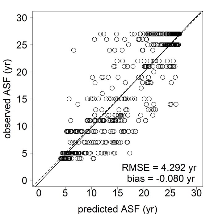
Relationship between observed and predicted age of secondary forests (ASF) resulting from fitting a machine learning algorithm with Landsat 5 TM and ALOS PALSAR data from 2010. Root mean square error (RMSE) and bias are also indicated, with the solid line representing the fitted linear model between predicted and observed ASF and the dashed line the perfect agreement. Adapted from Carreiras et al. (2017a).
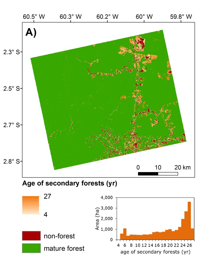
Map of estimated age of secondary forests in Manaus (2010) obtained by modelling Landsat 5 TM and ALOS PALSAR data with a machine learning algorithm (Random Forests).
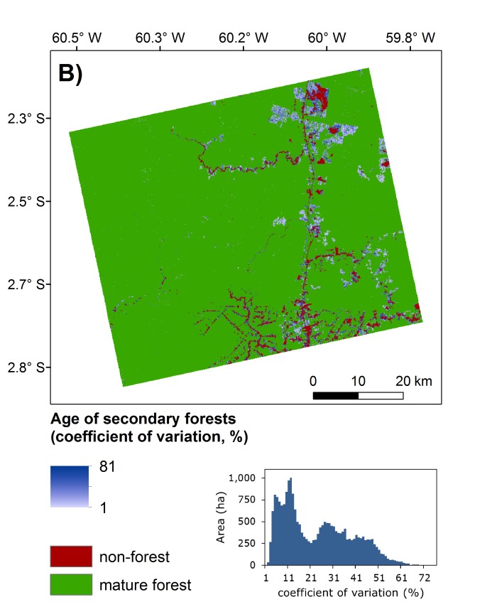
Map of coefficient of variation of the estimates. Non-forest and mature forest is also shown. The histograms depict the area (ha) by age of secondary forests (yr) and corresponding coefficient of variation (%). Adapted from Carreiras et al. (2017a).
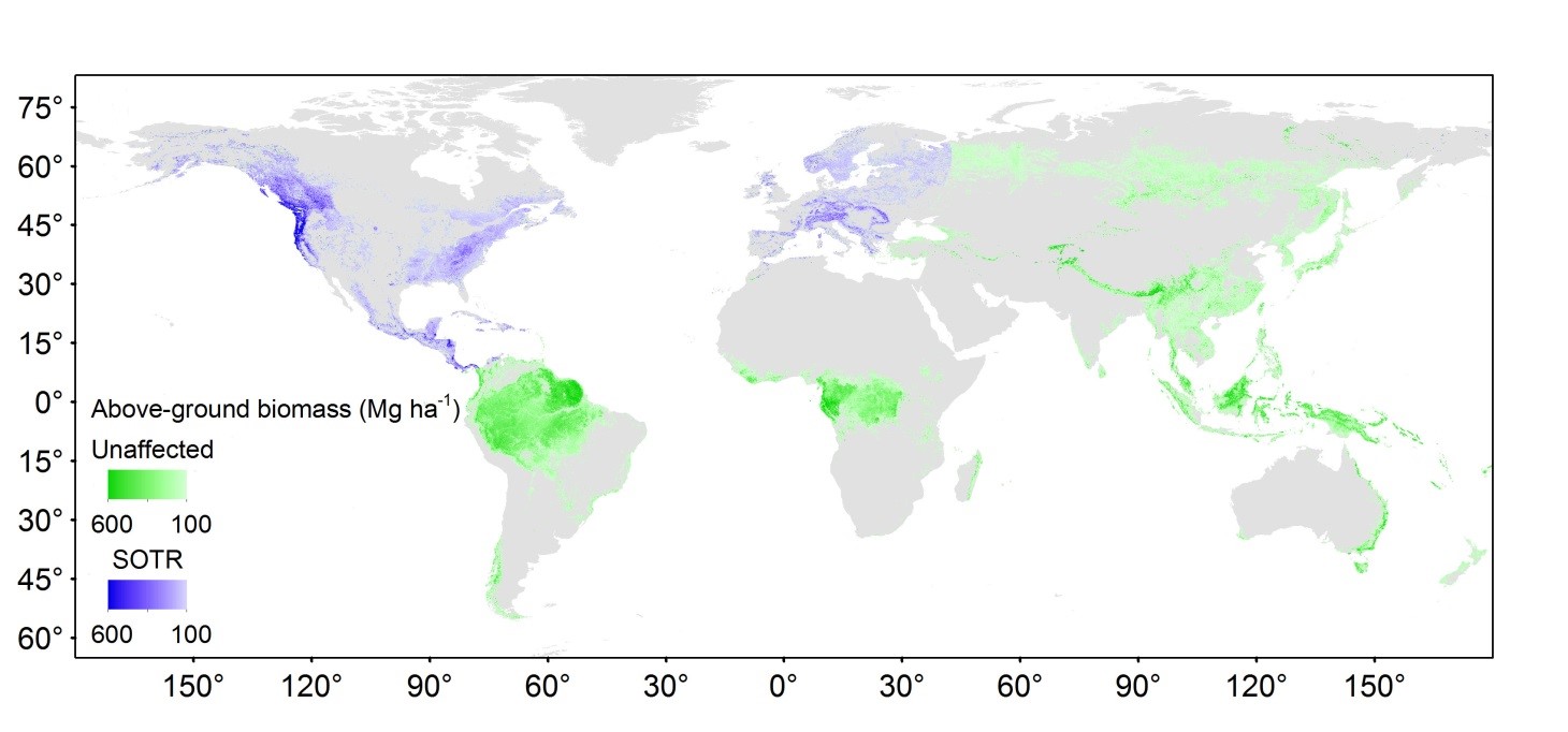
Spatial distribution of above-ground biomass (from Saatchi et al., unpublished results) between 65° S and 85° N in forested areas (from Hansen et al., 2013) with tree cover not < 25% and above-ground biomass density over 100 Mg ha-1. The green colour ramp shows the regions unaffected by the Space Objects Tracking Radar (SOTR) stations while the blue colour ramp shows those that are affected.
Improving biomass estimates in the tropics
The BIOMASS mission, with an expectation to launch in 2021, is ESA’s 7th Earth Explorer mission. Its main objective is to greatly improve the retrieval of above-ground biomass in the tropics, where uncertainty is much greater compared to all the other forest biomes, and where in situ measurements are limited.
The mission will deliver three primary geophysical products every six months: maps of forest above-ground biomass density and forest height at 200 m spatial resolution, and maps of severe forest disturbances at 50 m spatial resolution.
Mission restrictions and coverage
A problem the mission has encountered is that active sensors using this frequency cannot be operated within line-of-sight of registered P-band ground stations in North America and Europe, which form the network of Space Objects Tracking Radars (SOTR) under the control of the United States Department of Defense.
The initial selection of BIOMASS by ESA was made in full knowledge of the SOTR restrictions, which prevent imaging of Europe, North and Central America. Carreiras et al. (2017b) using the most up to date datasets of forest cover (Hansen et al., 2013) and above-ground biomass (Saatchi et al., unpublished results) provide the most comprehensive analysis of the impact of SOTR stations in terms of loss of forest coverage and how representative the unaffected regions are as regards above-ground biomass carbon stocks.
Under these restrictions, the authors concluded that only 3% of above-ground biomass carbon stock coverage is lost in the tropical forest biome, with this biome representing 66% of global above-ground biomass carbon stocks in 2005. The loss is more significant in the temperate (72%), boreal (37%) and subtropical (29%) biomes, with these accounting for approximately 12%, 15% and 7%, respectively, of the global forest above-ground biomass carbon stocks. Figure 3 clearly shows that the impact of SOTR restrictions is not a problem for the coverage of tropical regions, the main objective of the BIOMASS mission.
Joao Carreiras is a researcher at NERC’s National Centre for Earth Observation (NCEO) and based at the University of Sheffield. This work has been published in Remote Sensing of Environment:
Carreiras, J.M.B., Jones, J., Lucas, R., Shimabukuro, Y.E. (2017a). Mapping major land cover types and retrieving the age of secondary forests in the Brazilian Amazon by combining single-date optical and radar remote sensing data. Remote Sensing of Environment, 194, 16–32. https://doi.org/10.1016/j.rse.2017.03.016
Carreiras, J.M.B., Quegan, S., Le Toan, T., Ho Tong Minh, D., Saatchi, S.S., Carvalhais, N., Reichstein, M., Scipal, K. (2017b). Coverage of high biomass forests by the ESA BIOMASS mission under defence restrictions. Remote Sensing of Environment, 196, 154–162. https://doi.org/10.1016/j.rse.2017.05.003