A new paper led by Dr Simon Proud, research fellow at the Oxford University Department of Physics and the National Centre for Earth Observation, describes an unprecedentedly cold temperature measured atop a severe thunderstorm cloud in the Pacific by an Earth-orbiting satellite. This temperature of -111°C is more than 30°C colder than typical storm clouds and is the coldest known measurement of storm cloud temperature.
In the lowest section of the Earth’s atmosphere, known as the troposphere, air temperature decreases with altitude and can reach as low as -90°C in the tropics. Thunderstorms and tropical cyclones can grow to high altitudes, up to 18km (11mi), and therefore the tops of these storm clouds become extremely cold. Temperature measuring sensors aboard Earth-orbiting satellites can detect these cold clouds: Enabling meteorologists to monitor such storms and issue severe weather warnings.
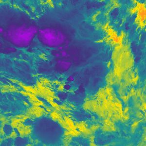
VIIRS infrared view of storms near Nauru on 29th December 2018. The coldest portions of cloud are purple while the warm Pacific Ocean is orange
On 29th December 2018, the VIIRS sensor aboard the American NOAA-20 satellite, overflew a severe thunderstorm in the South Western Pacific, approximately 400km South of Nauru. This storm was so powerful that it pushed through the troposphere and into the stratosphere; continuing to cool as it gained height despite the surrounding air being warmer: An event known as an overshooting top. This overshoot led to the storm cloud becoming the coldest known storm cloud temperature recorded, -111°C, and the tops of the clouds reached an altitude of over 20.5km (12.8mi) above sea level.
‘This storm achieved an unprecedented temperature that pushes the limits of what current satellite sensors are capable of measuring’ Dr Proud explains. ‘We found that these really cold temperatures seem to be becoming more common – with the same number of extremely cold temperatures in the last 3 years as in the 13 years before that. This is important, as thunderstorms with colder clouds tend to be more extreme, and more hazardous to people on the ground due to hail, lightning and wind. We now need to understand if this increase is due to our changing climate or whether it is due to a “perfect storm” of weather conditions producing outbreaks of extreme thunderstorms in the last few years.’
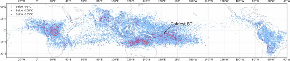
Map of all extremely cold cloud temperatures detected by NASA's Aqua satellite between 2004-2020
The success of VIIRS in identifying these cold temperatures is due to its ability to measure on exceptionally detailed spatial scales. Co-author Scott Bachmeier, a research meteorologist at the Cooperative Institute for Meteorological Satellite Studies/Space Science and Engineering Center, University of Wisconsin-Madison, explains that “since the coldest portion of a cold overshooting top turret can sometimes be 1 km or less, the superior spatial resolution of polar-orbiting satellite instruments (such as VIIRS and MODIS) provides a more accurate detection of the overshooting top’s thermal characteristics compared to instruments carried aboard geostationary satellites” that are more commonly used for weather monitoring. Upcoming satellite missions, such as EUMETSAT’s MetOp-Second Generation, will allow even more detailed analysis of future extreme storm events.
The work of NCEO staff in understanding uncertainty and designing future satellite missions is vital to monitoring such cold clouds: Sensors are less accurate at cooler temperatures and without accurate knowledge of this uncertainty our ability to monitor whether extreme storms are becoming more frequent is hampered.
Dr Proud’s work is supported by the Natural Environment Research Council.
The full paper is published in Geophysical Research Letters and is available via open access at: https://agupubs.onlinelibrary.wiley.com/doi/full/10.1029/2020GL092261
An article by the BBC can be found here