
News and Media
Arctic Adventures: Navigating to Nuuk to Advance Surface Temperature Science
Instagram @weather.and.climate.with.abi | X: @trynottocryo | X: @SurfaceTempUoL

Hello again, we’ve met before, right? For those who don’t know, I’m Abi, and since the last Arctic Adventure to Svalbard, I am pleased to say I am officially no longer a PhD student!
I somehow survived the thesis, viva and minor corrections, and yes, I have definitely been making the most of my shiny new title of ‘Dr’ on everything. I was very fortunate to be offered a role as a Land and Ice Surface Temperature Research Associate, which means I’ve stayed on in the Surface Temperature group (yay!) here at the University of Leicester, based at Space Park Leicester. You can find a more in-depth summary of our research group, NCEO and the University of Leicester in my previous Arctic Adventures blog here.
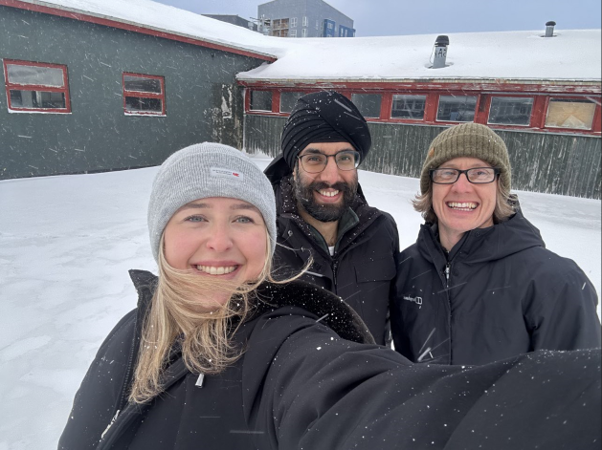
As with our last radiometer deployment, I was joined by our research group lead, Darren Ghent, and validation scientist Jasdeep Anand. This time, however, our expedition took us to Greenland!
Where and Why
We know that in-situ validation stations are vital for providing ground-truth measurements of the surface, allowing us to build confidence in our satellite datasets. There were several reasons why we chose Greenland, and in particular Nuuk these included:
- There wasn’t a dedicated Land Surface Temperature (LST) validation station, which meant key surface types in Greenland were underrepresented. In LST science, understanding surface type is crucial for accurately characterising its temperature.
- Although Greenland is climatically classified as part of the Arctic, it experiences different atmospheric and surface processes due to its size, geography and location compared with regions such as Svalbard and Arctic Scandinavia. This makes Greenland particularly important for assessing the wider climate context of our LST datasets and improving our understanding of how satellite observations perform across different Arctic environments.
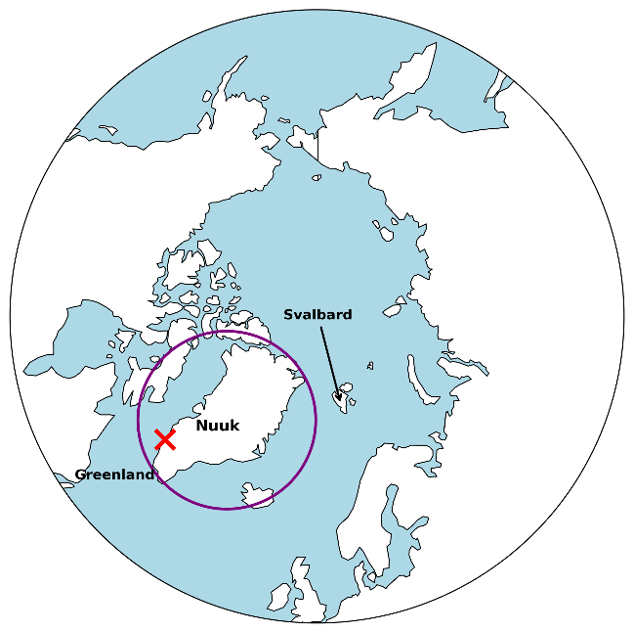
- Nuuk Greenland’s capital, has a subarctic maritime climate strongly influenced by the cold Labrador Current and surrounding fjord systems. Winters are long, cold and snowy, with temperatures commonly below freezing from October to April, while summers are short, cool and often variable, with temperatures typically between 5–15°C. The weather can change rapidly due to passing low-pressure systems from the North Atlantic, bringing strong winds, fog, snowfall and occasional clear, calm conditions under Arctic high pressure. Despite its high latitude, Nuuk is generally milder than many inland Arctic regions because of the moderating influence of the ocean.
- Nuuk was founded in 1728 by the Danish-Norwegian missionary Hans Egede and was originally named Godthåb (“Good Hope”). The area, however, has been inhabited by Inuit peoples for thousands of years, with strong traditions of fishing, hunting and adaptation to Arctic environments. Today Nuuk is Greenland’s political, economic and cultural centre, combining modern Arctic infrastructure and research institutions with Inuit heritage, and plays an increasingly important role in Arctic climate science, governance and environmental monitoring.
- Nuuk was selected due to its suitability criteria. Not only was its location relatively easy to access via commercial airlines, but it was also home to the Asiaq Greenland Survey. Asiaq is Greenland’s national survey and environmental data organisation, owned by the Greenlandic Government and based in Nuuk. They collect, analyse and manage data on Greenland’s physical environment, including climate, remote sensing and geotechnical conditions. Asiaq also supports climate monitoring and Arctic research through long-term observation networks across Greenland, providing data used for infrastructure planning, environmental management, climate adaptation and international scientific research.
- Members of Asiaq are also involved in the Nordic Snow Network (NSN), a Nordic-Arctic research collaboration led by the Finnish Meteorological Institute that brings together institutes, universities and Arctic organisations. The network supports snow and cryosphere research through the sharing of observations, modelling, remote sensing and climate data. By liaising with Anders, a climatologist at Asiaq, we were able to identify a series of available research stations for potential deployment. The Nuuk station site provided an easily accessible location with suitable conditions and met our surface, communication and power requirements.
The final hurdle was securing the funding needed to undertake this deployment. The instruments were provided through NCEO funding, but that was only half the battle. Thanks to the British Antarctic Survey (BAS), NERC Arctic Office and the UK Science and Technology Network, we were fortunate to be recipients of the “Supporting Impactful UK Arctic Science Engagement” fund. This programme supports UK researchers working collaboratively across the Arctic on themes including climate change, environmental monitoring and sustainable development, helping to strengthen international Arctic science partnerships and engagement with the Arctic Council community.
This funding was essential in supporting our research endeavours, and without it, this deployment would not have been possible. Now that we had our location, station, logistics and collaborations all sorted, the last job was to get there and set it up…
Navigating to Nuuk
The first leg of our trip was a three-hour flight from London Heathrow to Reykjavik, Iceland. After a mild panic involving an almost lost bag, we somehow managed to race through security and make our connecting Air Greenland flight to Nuuk.
Our layover was supposed to be just one hour, however a series of events meant we were delayed by around two hours. Already excited to cross the Labrador Sea and see Greenland with my own eyes, you would imagine this delay was an unfortunate setback. In reality, it turned out to be quite the opposite. The delay was caused because some passengers had brought too much luggage (I promise, it wasn’t us!). Eventually, we boarded our twin-engine turboprop Dash-8 plane, and yes, it was every bit as cool as it sounds. Around 20 passengers, including us, squeezed into snug seats arranged in two rows of two, all wide-eyed and excited for the journey ahead.
For roughly two hours, I stared out across the ocean, watching the sun sink lower in the sky above endless sea-ice floes. It is a very strange feeling seeing features like this in real life that you have previously only observed through satellite data. In that moment, I felt incredibly grateful to once again be given the opportunity not only to advance science, but also to experience something so unique and memorable.
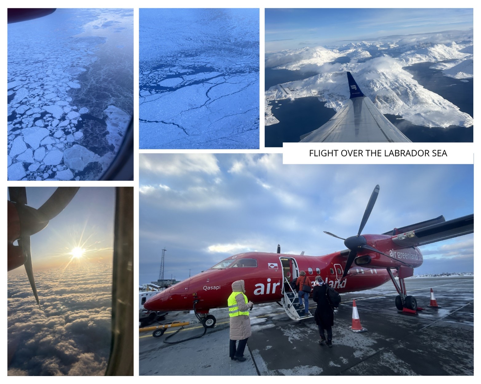
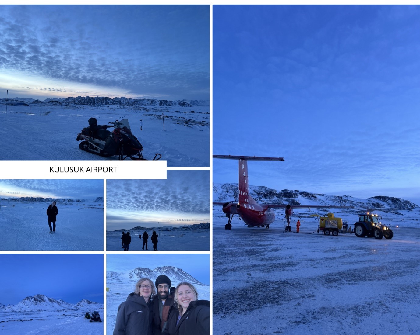
As a result of the extra weight from the additional luggage, we were informed that the plane would need to land in Kulusuk, on the east coast of Greenland, to refuel. This, however, turned out to be the not-so unfortunate part of the delay…
As we flew closer to Greenland’s east coast, sea ice gradually turned into vast ice shelves, which then gave way to rugged land. Stepping off the plane at Kulusuk Airport felt like stepping onto another planet. You know Mann’s Planet from Interstellar? Yep, really! As we quite literally jumped out of the plane with excitement, I remember thinking to myself, how is a place like this even real? Let me paint the picture…
The sun was setting behind the coastal hills, casting a golden glow across the airport. Everything, from the ground beneath our feet to the distant horizon, sparkled with ice and frost. As we made our way towards the airport building, another passenger spotted a back door leading to a viewing area. The moment we stepped outside; gasps of amazement broke the serene silence. At this point, I must have said “wow” about twenty times. A blanket of snow and ice stretched across the landscape as far as the eye could see. The combination of complete stillness and overwhelming excitement was enough to bring tears to your eyes.
We were only in Kulusuk for around thirty minutes before being called back to board the plane. As we took off once again, I looked back one last time, and it hit me that I would likely never have the opportunity to experience a place like this again. In that moment, I realised just how grateful I was for this not-so unfortunate delay, and that enjoying the journey can be just as important as enjoying the destination.
The final leg of our journey to Nuuk took us across the south-western Greenland Ice Sheet for another hour, before we finally landed and enjoyed an unexpectedly scenic taxi ride to our hotel. We had made it! Now it was time for science!
Day 1 – Preparation and Installation
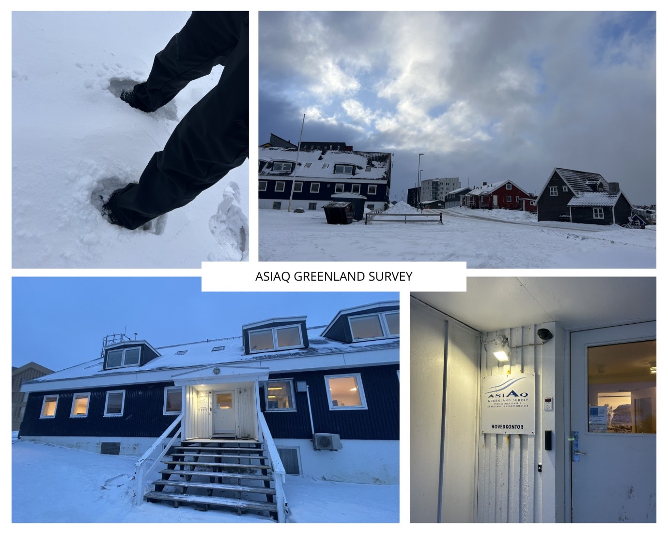
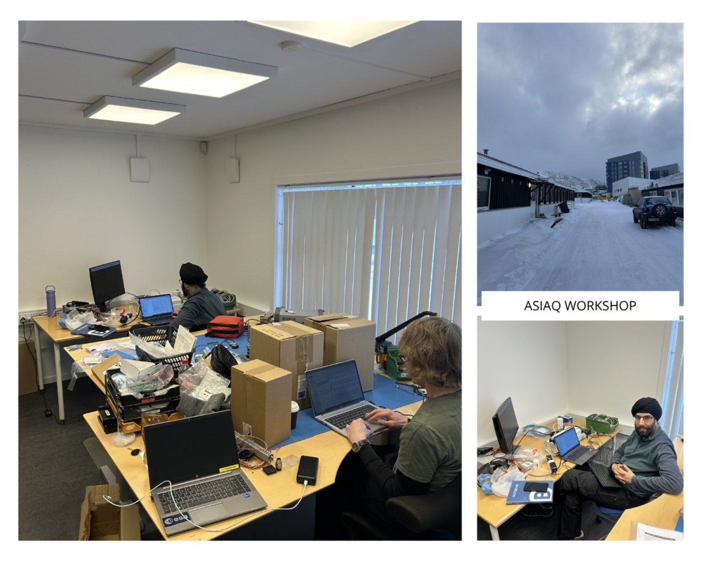
As part of the research collaboration with Asiaq, we were very kindly provided access to their workshop and offices to carry out our preparations for the instrument installation. Since we only had three full days to complete the deployment, we were keen to organise our time carefully. We were also aware that severe weather was forecast for day three, which effectively meant we had around one and a half days to prepare everything, with the aim of completing the installation on day two and leaving time for checks and troubleshooting on day three.
Day One
The first day of any deployment is almost always spent assessing the site and beginning the setup process. In the morning, the team got to work preparing the radiometers. As with previous deployments, Jasdeep led the dry run, while Darren and I provided extra help where needed. This included unpacking the instruments, locating the correct tools, preparing the software, wiring everything up and testing the connections.
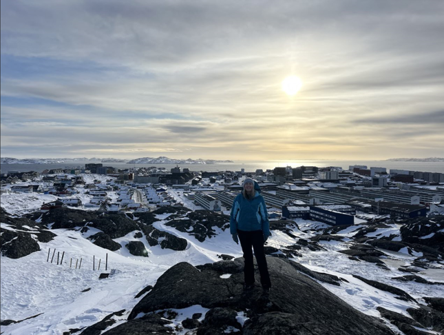
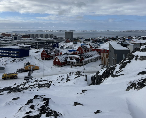
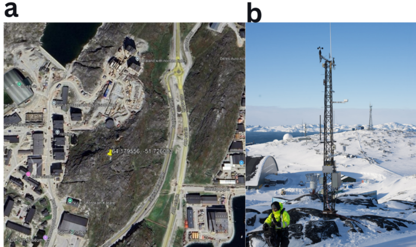
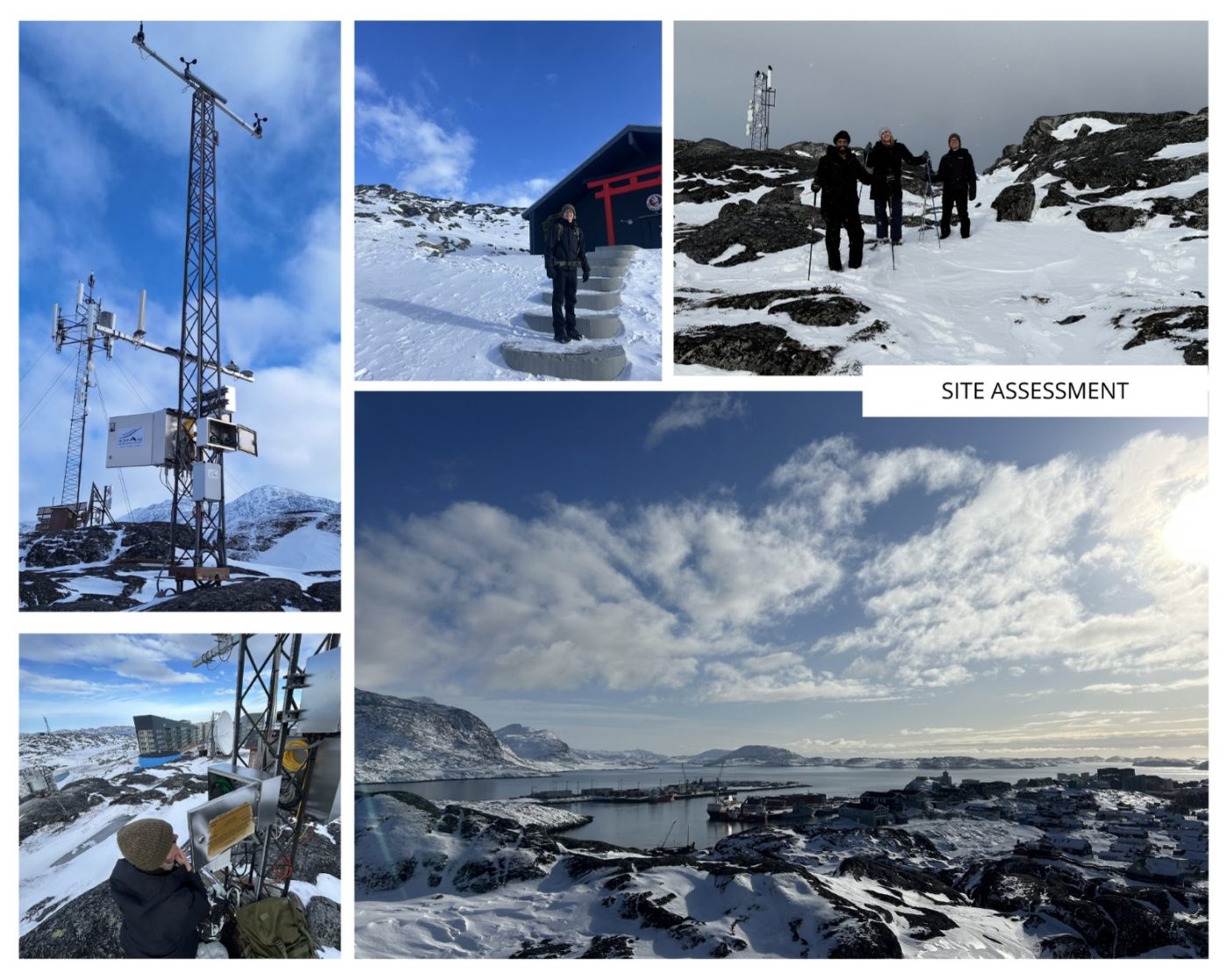
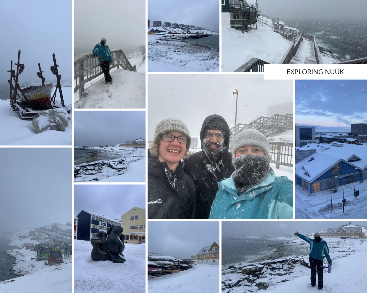
In the afternoon, it was time to visit the site. The site was located on a hill in central Nuuk (64.18°N, 51.73°W; elevation 81 m). After a short ten-minute walk up the hill, albeit through the snow, we were rewarded with incredible 360-degree views across Nuuk. It was hard not to simply stand and stare in awe. We could see fjords, glaciers, villages and everything in between. Since this deployment took place in mid-March, the local weather was highly variable. One minute it could be mild with crisp clear skies, and the next it could turn into a blizzard. Luckily, during our couple of hours on the hill, the skies remained clear and the winds calm. Absolutely stunning.
Whilst it might seem like I can get overly excited about the views (no comment), it was important that we made good use of our time and prioritised the science. Firstly, we assessed requirements such as power and connectivity, as well as identifying a suitable surface area for the radiometer to observe and take measurements from. We then needed to examine the area towards which the radiometer would be pointed. The surrounding surfaces are characterised primarily by exposed rock with small areas of soil and sparse low vegetation, providing a relatively representative and unobstructed view for radiometric measurements. The area was also covered in snow at the time, meaning we would be able to capture seasonal transitions of the surface throughout the year.
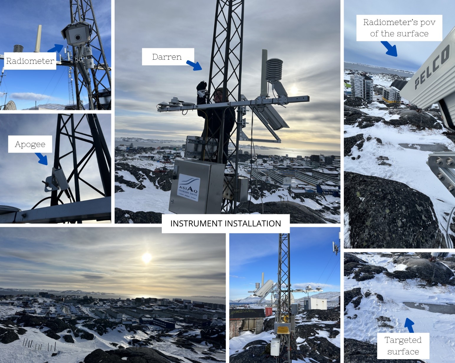
As part of the installation, we deployed a Heitronics infrared radiometer to measure upwelling thermal radiation emitted from the surface, alongside an Apogee pyrgeometer to measure downwelling longwave radiation from the atmosphere. Together, these measurements are essential for deriving accurate LST observations and supporting the validation of satellite-derived LST products. By continuously monitoring both the surface emission and atmospheric contribution, the station provides an important reference point for assessing satellite performance over Arctic environments, where validation opportunities are relatively limited. You can refer to my previous blog about our deployment in Svalbard here, for more information.
Although the site is publicly accessible, foot traffic is minimal, and positioning the instruments at the top of the mast would further reduce the likelihood of interference. The location is largely free from shadowing throughout the day, aside from brief periods caused by nearby masts and antenna structures. Importantly, both power availability and the accommodation of additional equipment were expected to present no significant issues.
Once we had completed our initial assessment, we headed back to the workshop for final preparations. A successful first day!
Day 2 – Preparation and Installation
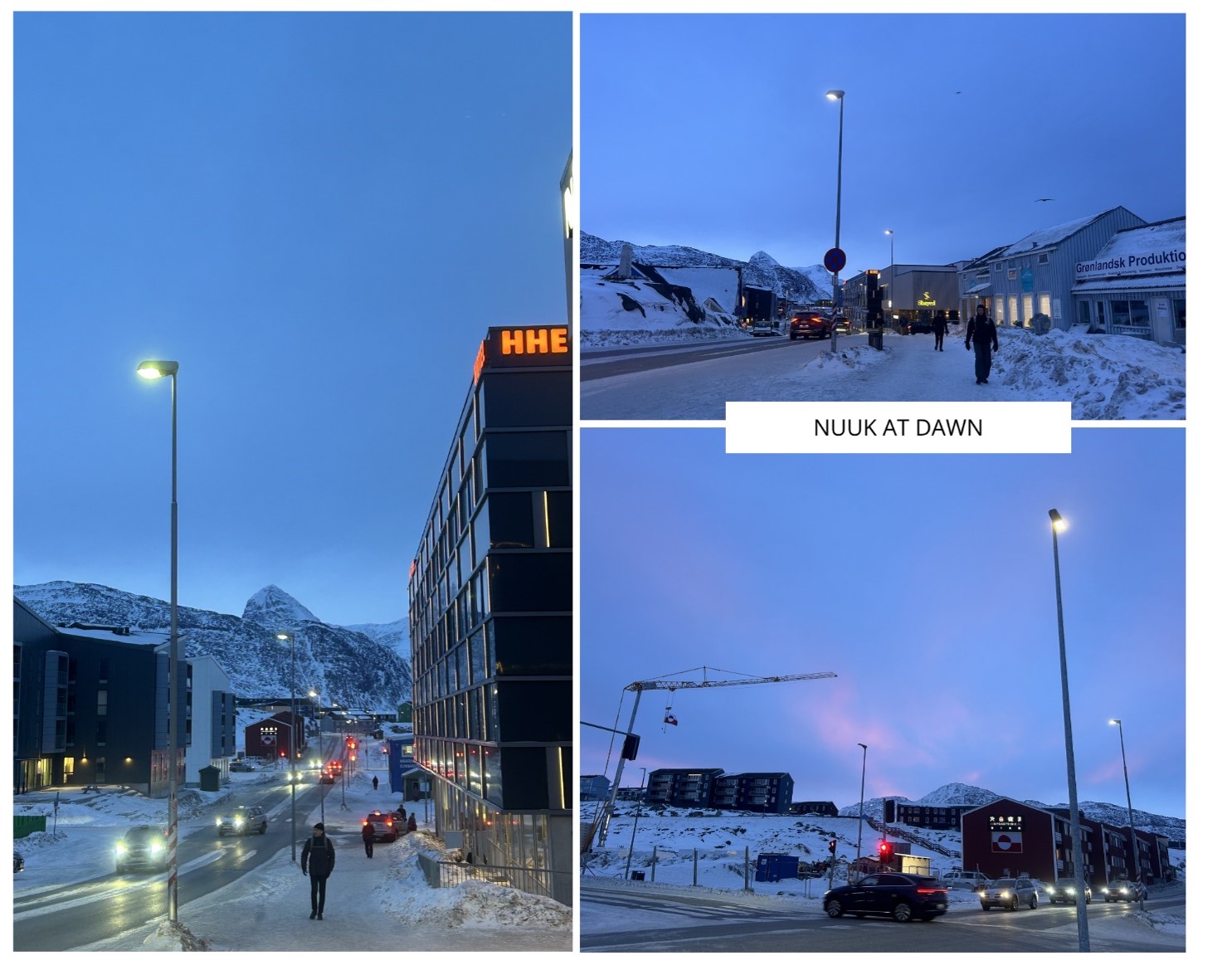
Up at the crack of dawn, two coffees deep and covered head-to-toe in thermal layers, we were ready for the day ahead. After a lovely stroll to the workshop just as the sun began to break through at dawn, we spent the first half of the day preparing for the installation.
I say this a lot, but preparation really is key! Not only do you need to thoroughly plan the logistics of your trip before you travel, it is just as important to do so during the deployment itself. Setting up new instruments in a new country, within a challenging environment, is extremely nuanced. Of course, Jasdeep (and our team) has done this so many times that he could probably do it blindfolded. However, that does not mean any scientist, is free from errors or unexpected issues. So, in order to prepare for a more challenging deployment and ensure it was completed safely and efficiently, we were extra thorough.
Due to our time constraints, we prepped and checked absolutely everything we could think of. We were swimming in nuts and bolts, spanners and screwdrivers, and bags full of wires and instruments. We even planned down to who would carry which bag, what equipment was needed for the hike up, and ran through “what if something doesn’t work?” scenarios. One of my jobs was to do some fun trigonometry (a strange combination of words, I know) to calculate the viewing geometry and field of view of the radiometer. By the time lunch came around, we were ready and raring to go.
Crampons on, walking sticks at the ready and backpacks full, we set off back up the hill to the station. Once again, the day was cool but fair, and the visibility was ideal. We got straight to work to avoid spending too long exposed in case the weather changed.
First, we attached the wires to the datalogger, which were then connected to the Heitronics and Apogee instruments. The instruments were then bolted onto the right-angled triangle frame, and we positioned everything at the correct location and height to observe the intended surface. Four hours later, with winds blowing, fingers freezing, and after a few rewires and adjustments, the setup was complete. This was followed by a triple check to ensure the instruments were reading and recording correctly, and that we could access the data remotely. The taste of success!
Time for one big high five for the team effort, some pictures of the instruments and, of course, the scenery. We made sure to soak in the incredible view one last time before our descent, heading back down into town with huge grins on our faces and ready for a well-earned cup of tea.
Day 3 – Inspecting and Exploring
On our final day in Nuuk, we woke up to the beginnings of a blizzard. The bird’s-eye views at breakfast were mesmerising, with large snowflakes, thick snowfall and dark, foggy skies. Our walk to the workshop felt like stepping into a snow globe. I was absolutely in my element, as per usual. Although the cloud cover during our time there meant we were unable to catch a glimpse of the Aurora Borealis, experiencing winter in Greenland was more than enough.
Our final day was spent hard at work checking that the sensors were still operating correctly, fixing minor software bugs, extracting the new data recorded since installation, and making final notes on the local climate context of the region. Thankfully, everything was running smoothly, meaning we could officially deem the deployment a success.
That afternoon, we gave a brief presentation to colleagues at Asiaq. It is important to share science, not only for scientific advancement, but also to strengthen collaborations, encourage critical thinking and open dialogue around potential applications and impacts. We are incredibly grateful to Anders and the wider Asiaq team for their hospitality and collaboration. Without access to their station and facilities, this deployment would not have been possible.
After we had packed up and said farewell to the Asiaq team, we wanted to make the most of our final evening, despite the snow. This meant one thing, and one thing only: tourist time! I don’t think I have ever hunted for a fridge magnet so enthusiastically in my life. Nuuk is a small city, with only one supermarket and one tourist shop, and we all know you haven’t really been somewhere unless you come home with a magnet and a photo… right?
Significance of LST in Greenland
The installation of the radiometer in Nuuk represents an important step in improving the validation and understanding of satellite-derived LST observations in the Arctic. Ground-based radiometers provide highly accurate surface temperature measurements that can be directly compared against satellite observations, helping to quantify uncertainties and improve the reliability of climate datasets in high-latitude environments. This is particularly important in Greenland, where complex terrain, snow cover, low solar angles and rapidly changing surface conditions can make satellite retrievals especially challenging. Long-term observations from installations such as this help strengthen Arctic climate monitoring and improve our understanding of how surface temperatures are responding to ongoing climate change.
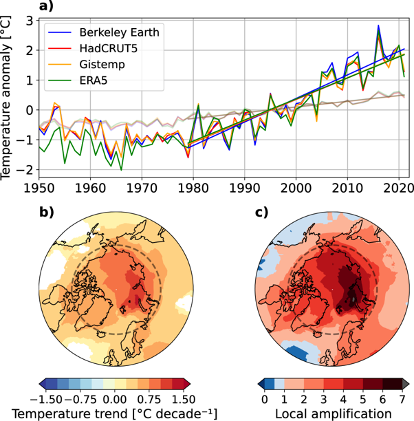
Greenland is already experiencing some of the most rapid climate change on Earth. Arctic temperatures are increasing at around four times the global average rate in a process known as Arctic amplification, with Greenland seeing substantial warming over recent decades. The Greenland Ice Sheet has been losing mass at an accelerating rate, contributing significantly to global sea-level rise, while reductions in snow cover duration, sea ice extent and glacier stability are continuing to alter Arctic environments and ecosystems. Increasing surface melt events and warmer air temperatures are also affecting infrastructure, hydrology and coastal communities across Greenland. These changes highlight the growing importance of sustained in situ observations alongside satellite monitoring to better understand how Arctic surface conditions are evolving through time and to improve the accuracy of long-term climate records.
These changes are not confined to Greenland alone, but form part of a wider shift in the Earth’s climate system and global energy balance. As snow and ice melt, the surface becomes darker and absorbs more incoming solar radiation rather than reflecting it back to space, reducing the Earth’s albedo and further enhancing warming through a positive feedback mechanism. Changes in Arctic temperatures and sea ice can also influence atmospheric circulation, ocean circulation and weather patterns beyond the polar regions, highlighting the strong interconnectedness between the Arctic and the global climate system.
Equally important is the role of collaboration and engagement with local Greenlandic and Indigenous communities. Inuit communities across Greenland have lived in and adapted to Arctic environments for thousands of years, with deep knowledge of local weather, snow, ice and seasonal environmental change. As Arctic research activity continues to grow, it is essential that scientific projects are undertaken respectfully and collaboratively, recognising that research is being conducted on Indigenous land and within communities directly affected by climate change. Establishing open dialogue with local organisations and residents helps ensure that monitoring activities are transparent, locally relevant and mutually beneficial.
Environmental monitoring stations such as this have the potential to support local communities through improved understanding of changing climate conditions, surface temperatures, snow and ice variability and extreme weather. These changes can affect transport routes, infrastructure stability, water resources and traditional activities such as hunting and fishing. By encouraging communication with local partners about how the observations and data products may be useful to them, the project aims not only to advance satellite climate science, but also to contribute towards longer-term environmental resilience and knowledge sharing within Arctic communities.
As part of this work, we are endeavouring to place greater emphasis on communication and long-term engagement with Indigenous communities and local organisations throughout the project lifecycle. By listening to local perspectives and encouraging open discussion around how environmental monitoring stations and satellite observations may support community priorities, we hope to ensure that the research remains respectful, relevant and beneficial beyond purely scientific objectives. We also recognise the importance of building stronger collaborative relationships between researchers and Arctic communities, particularly as climate change increasingly affects daily life, infrastructure, travel and traditional practices across Greenland. Through continued dialogue and knowledge sharing via blogs, articles and engagements, projects such as this can help strengthen both scientific understanding and local climate resilience while ensuring Indigenous voices remain central within Arctic environmental research.
Research Trip Round-Up
As we flew home via a one-night stopover in Reykjavik (yep, I love my job), it was hard not to reminisce about our incredible experience. Greenland has been on my bucket list ever since I decided I wanted a career in weather and climate, especially after the two-week field expedition I was supposed to go on during my master’s degree was cancelled due to COVID. It was extremely gratifying to have had the opportunity not only to visit Nuuk, but also to help drive the deployment trip from start to finish. If you needed a sign that you really can make things happen, this is it!
That being said, we extend our thanks to NCEO for funding the instruments, the NERC/BAS grant, the Nordic Snow Network connections, and the collaboration and facilities provided by Asiaq, with a special thanks to Anders. I would also personally like to thank my supervisor, Darren, and Jasdeep, for allowing me to drag them around the Arctic in the name of science. These deployments would not have happened without their expertise in climate and validation science, so it truly has been a team effort.
Not only has this been a personal success, but a professional one too. This validation station is now the fourth Arctic deployment we have led, including Svalbard, Arctic Sweden and Arctic Finland. These measurements are imperative for validating satellite datasets and increasing confidence and reliability in our work. We hope that establishing long-term monitoring stations, not only in the Arctic but across the world, will continue to support scientific advances that directly impact real people, real-world decision making, policy, adaptation and mitigation.
Now that we have returned home, I have found myself juxtaposed between gratitude for the experience and sadness at witnessing the effects of climate change first-hand. It has given me even more motivation to continue researching, exploring and contributing to meaningful science.
As I sit here writing this blog, reminiscing on the icy scenery and fjord bays, I wonder where next we can conquer. Antarctica, perhaps? Who knows, watch this space…
Until then, I will be waiting patiently and hoping to once again be lucky enough to return to the Arctic for science. Until next time!
Share this article


Published by Fazila patel
Digital Comms Officer
University of Leicester


Latest News and Events
