
News and Media
Grassland community types in sustainable land management and the maintenance of pastoralist livelihoods

Today is World Environment Day and we are celebrating by research summary of a recent paper co-authored by our own Professor Heiko Baltzar. The study, published in Frontiers (Front. Sustain. Food Syst., 27 May 2025. Sec. Land, Livelihoods and Food Security) last month, explored the role of grassland community types in sustainable land management and the maintenance of pastoralist livelihoods in Kenya. Semi-arid grassland ecosystems are crucial for biodiversity, carbon sequestration, and animal fodder; but are increasingly placed under pressure by overgrazing and climate variability. The aim of the study was to map grassland communities and assess their palatability in semi-arid Kenya using Multiple Endmember Spectral Mixture Analysis (MESMA) and sentinel-2 satellite imagery. They also imbedded species abundance with forage quality metrics. Their findings provide actionable insights for sustainable grazing management and land protection.
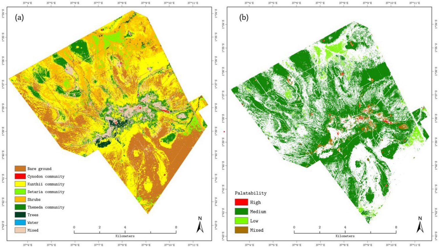
Mapping grassland communities provides a comprehensive understanding of the ecosystems structure and function, which is important for sustainable land-management and allows for more informed decisions about grazing patterns. Sentinel-2 imagery was processed using MESMA to classify the cover of four key grass species (Cynodon, Setaria, Themeda and Kunthii), along with non-grass land cover types (bare ground, forests, shrubs, and water). MESMA does this by distinguishing the unique spectral signatures each grass species and community give off. Palatability was assessed based on chemical analysis from pre-existing literature and pastoralists’ perceptions of the forage quality. Their results suggest MESMA’s is effective in capturing grassland heterogeneity and are useful in providing insights into sustainable grassland management that support pastoral livelihoods as well as ecological balance.
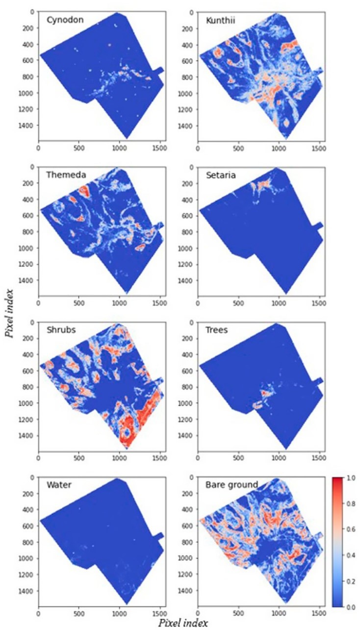
Figure 1. illustrates the evaluation of the unoptimized Endmember MESMA classification in comparison to ground observations. The unoptimized MESMA model attained an overall RMSE of 23.5%, resulting in a 6% improvement in classification accuracy. Significantly, the RMSEs for principal grassland classes, such as Cynodon and Setaria, were below 25%, facilitating more accurate spatial mapping of palatable grasses. The model yielded RMSEs of 25 and 29% for bare ground, Cynodon community, and tree cover, respectively, while shrubs, Kunthii, and Setaria communities demonstrated higher RMSE values of 32, 33, and 34%, respectively.
The findings will support policymakers to design grazing plans that align with the seasonal forage availability and reduce pressure on degraded and degrading areas. Management policies can better support biodiversity conservation, integrating these insights into wider climate adaptation frameworks may even support ecosystem resilience and ensure food security.
The study will also allow for the MESMA framework to be implemented across other semi-arid regions of East Africa, though regional weather and soil types may require more validation.

Figure 2. Vegetation composition and forage palatability at Kapiti Research Station derived from optimized endmember MESMA. (a) Dominant land-cover and plant communities: Bare ground (brown), Cynodon spp. community (red), Kunthii spp. community (yellow), Setaria spp. community (light green), Shrubs (orange), Themeda spp. community (dark green), Trees (forest green), Water (blue) and Mixed cover (beige). (b) Grassland palatability classes: High (red), Medium (dark green), Low (light green) and Mixed (brown).
The findings of this study illustrate the effectiveness of MESMA in the field of remote sensing and highlight’s Sentinel-2’s capacity to yield crucial information on spatial heterogeneity, fundamental to understanding vegetation dynamics and productivity within these intricate and changing ecosystems. Not only is this knowledge useful for preventing land degradation but it also offers a tool for targeted restoration, such as identifying areas that could be reseeded. This study offers actionable insights into sustainable grazing management and will provide policy makers with essential data to target land restoration and overgrazing, enhancing both environmental welfare and the livelihoods of pastoral communities.
Share this article


Published by Rose Meadows
Outreach Officer
University of Leicester
Latest News and Events
