Understanding how landscapes evolved through time following different land use activities, policies and anthropogenic pressures is essential to identify potential ecological impacts, such as biodiversity and habitat loss, and to support efficient policy design.
It is critical to know how the spatial patterns of conversion change over time, as both patchiness and total amount of remaining habitat can have distinct impacts on biodiversity, and carbon storage can vary two to four-fold depending on the emerging pattern.
The Brazilian Amazon has been subjected to extensive deforestation in the past four decades. Annual deforestation mapping generated from satellite data has been made publicly available by the Brazilian National Institute for Space Research (INPE) since 1988 within the scope of the PRODES project.
Reported deforestation rates have been highly variable over time, reaching its highest value in the mid-1990s (~30,000 square kilometres per year), but decreased progressively since the mid-2000s up to a record low of ~4500 square kilometres per year in 2012. These fluctuations can be attributed to the combination of many socio-economic factors, which varied over time. In particular, between the 1970s and 1980s, deforestation was mainly a result of government-sponsored initiatives to colonise the region, which featured extensive road building, granting land titles to settlers and tax incentives. Beginning in the 1990s, and up until today, national and international demand for commodities such as soybeans and beef started playing a stronger role in the temporal variations of annual deforestation rates.
Most of the deforested area is currently under agricultural use, especially for cattle ranching. However, land abandonment has occurred in many areas, allowing the expansion of secondary succession forest of different ages.
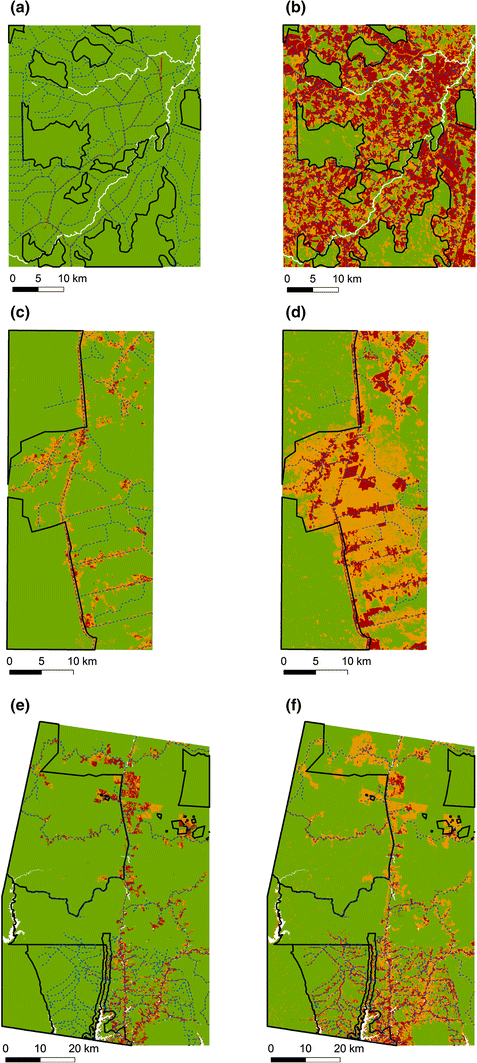
Land cover (mature forest—green, non-forest—red and secondary forest—orange) at the beginning and by the end of our time period of analysis in Machadinho d’Oeste: a 1984 and b 2011, Santarém: c 1984 and d 2010, and Manaus: e 1985 and f 2011. Black solid lines show the boundaries of the conservation units; blue dashed lines show the road network in 2010
We examined the temporal and spatial dynamics of forest fragmentation in three study areas across the Brazilian Amazon (Manaus, Santarém and Machadinho d’Oeste), both inside and outside conservation units.
We compared the impacts on the landscape of: (i) different land uses (e.g. cattle ranching, crop production), (ii) occupation processes (spontaneous vs. planned settlements) and (ii) implementation of conservation units.
Time-series of 3-class land cover maps (mature forest, non-forest and secondary forest) were used to carry out the analysis. These were obtained by automatically classifying Landsat data acquired over the three selected sites from the mid-1980s to 2010/2011 at annual time steps. We chose a minimal set of uncorrelated fragmentation metrics to capture landscape configuration (e.g. area, shape) and aggregation across time: edge density (ED), clumpiness index (CLUMPY), area-weighted mean patch size (AREA_AM), and area-weighted mean patch shape index (SHAPE_AM).
By the end of the time-series, mature forest in Machadinho d’Oeste occupied only 32% of the landscape, 56% of which within conservation units, more than doubling the initial proportion of 23%. Santarém ended the time-series with about 46% of mature forest, 62% of which inside conservation units, whereas Manaus, by contrast, reached 2011 with 72% of mature forest evenly distributed inside and outside of conservation units.
Patches of mature forest decreased over time
At the beginning of the time period covered in this study, the largest patches belonged to mature forest in all landscapes. However, by 2010/2011 that was still true only for Manaus. In all three regions, a significant and sharp reduction in the AREA_AM values was observed for this land cover class outside conservation units. Conversely, we found a significant positive trend in the AREA_AM of secondary forest in all three regions, both inside and outside of conservation units, although higher outside.
In all three regions, and for all three land cover classes, ED was always lower inside conservation units than outside, throughout the time-series, and it increased over time (except for non-forest in Manaus). Machadinho d’Oeste showed the highest magnitudes of changes in ED for all three classes, both inside and outside conservation units. For the majority of the time steps (69%) in the time-series analysed, CLUMPY values were higher inside conservation units than outside, for all three land cover classes and in all three regions. This was particularly true for secondary forest (78%) and mature forest (75%). The results obtained for the SHAPE_AM metric showed a less clear trend for all three regions.
Our findings show that Manaus, which is located in the north-western part of the Amazon, far from the dynamic Arc of Deforestation, was the least fragmented landscape by the end of the time period. Nonetheless, an increasing edge density (ED) and a strong decrease in the patch area (AREA_AM) indices in the mature forest class indicate that the old-growth forest is indeed being fragmented. In Santarém and Machadinho d’Oeste, both located in areas where agro-businesses are well established, and road networks are extensive, mature forest now represents less than 50% the landscape and is almost strictly confined to conservation units.
Pressure on conservation units
While the overall pattern of the landscape metrics was similar inside and outside conservation units, showing a forest getting increasingly scattered and larger non-forest patches emerging over time, we still found important differences. In all three regions, fragmentation was more severe outside conservation units with higher increases in ED and steeper reductions in the area of mature forest. Although this suggests that conservation units have had a role in preventing further fragmentation, in agreement with previous findings, our analysis in Machadinho d’Oeste, the landscape that has undergone the highest land cover change, has shown that existing conservation units are suffering increasing pressure from deforestation activities due to significant reduction in unprotected forested areas.
The fact that Manaus was the least fragmented landscape can be explained in part by: (1) its isolation—road density in this municipality is much lower when compared to the municipalities in the Arc of Deforestation; and (2) by a lack of favourable conditions for agriculture—wetter weather and poorer soils.
However, the increasing trend in mature forest fragmentation in this region is most likely a result of a rise in agriculture activities. Santarém and Machadinho d’Oeste sites are very different from each other, and from the Manaus site, in terms of history of occupation and land use activities.
The rise of agro-business
Machadinho d’Oeste was a planned settlement part of a colonisation program implemented by the government in the 1980s. Past studies have shown that creating a new settlement has an immense impact on forest fragmentation, and Machadinho d’Oeste was no different. The people who live there nowadays depend heavily on agricultural activities for income, especially cattle ranching and coffee plantations. As a result, the number of cattle heads in Machadinho d’Oeste, according to the Brazilian Institute of Geography and Statistics, rose rapidly from nearly zero in the 1980s to more than 250,000 by 2010, representing a density of 0.31 heads per hectare.
The history of land use activities in Santarém, on the other hand, is closely related to the BR-163 road, which was built by the government in the 1970s, as part of the Amazon colonisation program. This allowed farmers to spontaneously establish themselves along this road. Initially, farmers in this region were mainly small-scale agrarian reform colonists. However, and despite being illegal, many of these farmers were pressured to sell their land to large-scale agro-businesses.
Land availability, the perspective of paving of the BR-163 road, thus having an easy way to transport their goods, and the existence of a port in the city of Santarém, turned this region into a very attractive location for agriculture activities, and associated unofficial road expansion. The area harvested of annual crops has risen rapidly since the early 2000s. This pattern is attributed to the fast expansion of soybean production in this municipality, supported by the improvements made on the Santarém port by Cargill. Such dynamics has significantly impacted the landscape, as our results show, with mature forest becoming fragmented into smaller and more irregular patches, thus resulting in larger edge densities.
The differences found among our study sites show that conservation policies designed to prevent further deforestation in the Brazilian Amazon need to account for temporal dynamics and location-specific processes and agents of land cover change, to ensure their success. Having detailed spatially explicit information to assess land use and land management impacts is the first critical step to understand historical changes and to be able to improve conservation policies.
Joao Carreiras is a researcher at NERC’s National Centre for Earth Observation (NCEO)/University of Sheffield. This work has been published in Regional Environmental Change.