In late June, an exceptional heatwave enveloped Western Canada and the North-Western United States, culminating in Canada recording its hottest ever temperature: 49.6°C in Lytton, British Columbia on 29th June. One day later, Lytton was destroyed by wildfires powered by the heat.
Using European and American satellites, NCEO researchers are contextualising these unprecedented conditions. The Infrared and Microwave scheme (IMS), developed by NCEO / RAL Space using data sent back by EUMETSAT’s MetOp weather satellites, recorded land surface temperatures of over 47°C in Alberta, Canada, and over 50°C in Montana, USA – despite the MetOp flying overhead midmorning, when temperatures are cooler than the afternoon peak.
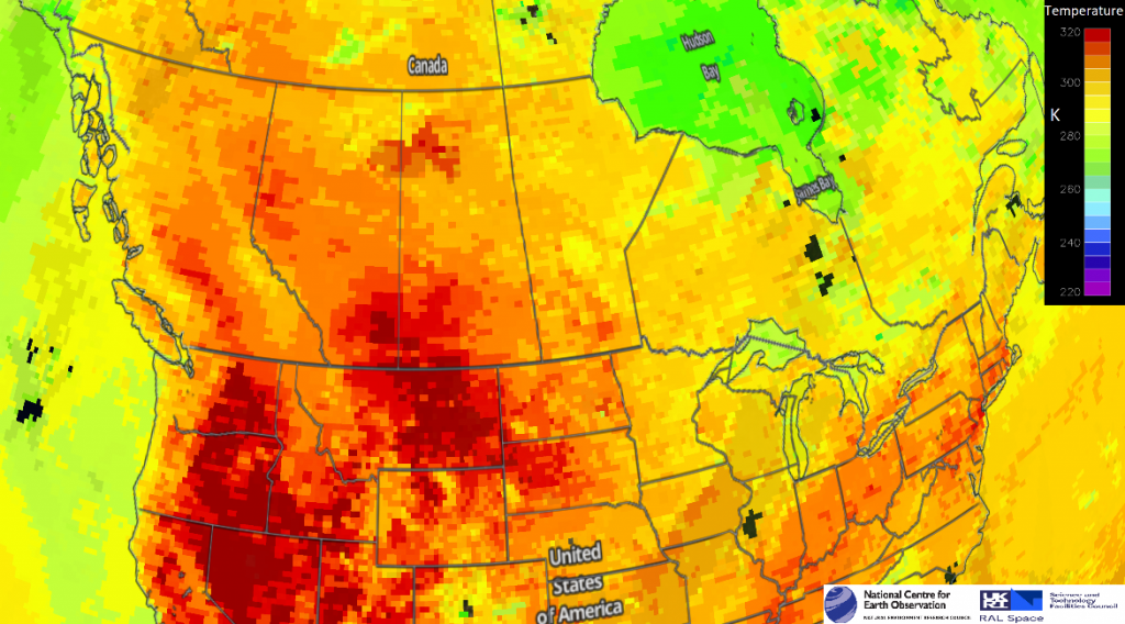
IMS land surface temperatures on 29th June 2021. Temperatures are in Kelvin
Professor Martin Wooster, Divisional Director at the National Centre for Earth Observation and Associate Director of the Leverhulme Centre for Wildfires, Environment and Society has noted that “Wildfires are a natural part of many North American ecosystems, but depending on their location they can post a risk to lives and infrastructure and have very severe consequences for air quality. The risk of extreme fire is typically greatest in hot, dry (and windy) conditions and the unusual weather is helping to drive these very severe wildfires. When such fires generate pyro-cumulonimbus clouds it is also possible to get lightning strikes that ignite further fires, expanding the severity of the event. Though satellite data records suggest that globally fire activity has overall reduced a little in the last 20 years, in temperate north America fire activity may have changed to become on average more extreme compared to that in the 1980’s and 1990’s.”
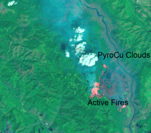
Image credit Dr Weidong Xu – a detailed view of the fires in the British Columbia Canada area, acquired by the Operational Land Imager (OLI) on Landsat 8 at about 12 p.m. local time (19:00 Universal Time) on June 30, 2021.
Using data from the GOES-17 weather satellite, NCEO Oxford tracked Pyro-cumulonimbus clouds – thunderstorms triggered by the wildfires – near Kamloops, BC. The Optimal Retrieval of Aerosol and Clouds algorithm, jointly developed by NCEO, RAL Space and Deutscher Wetterdienst, computed that the PyroCbs were powerful enough to punch through a natural ceiling on storm growth known as, the tropopause, to reach altitudes more than 17km.
An algorithm developed by Dr Simon Proud, NCEO and University of Oxford, detected Above Anvil Cirrus Plumes (AACPs) atop these clouds – a relatively uncommon phenomenon only found in severe storms that indicate transport of material from the lower atmosphere into the stratosphere: “Smoke and gases produced by the fires were injected into the stratosphere, where they can be blown by the wind for thousands of kilometres.
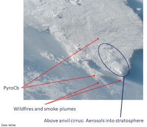
PyroCb clouds triggered by Canadian wildfires viewed by NOAA’s GOES-17 weather satellite.
One such gas produced by the fires is Carbon Monoxide, which is long-lived and so can be used as a tracer for the transport of air from the fires. The IMS also estimates carbon monoxide, and followed a plume of the gas as it travelled from Western Canada on the 1st July across the continent, dispersing over the United States on the 4th July.
Detecting and tracking such plumes is vital to improve our knowledge of atmospheric chemistry, giving insight into the breakdown of gases and how they interact with other atmospheric constituents to produce new gases and stratospheric ice clouds.
NCEO researchers continue to monitor the ongoing, devastating fires that continue across Canada and are now burning across large parts of the Western USA.
Images from the infrared and microwave system were produced on JASMIN using satellite data held on the CEDA Archive. CEDA/JASMIN services are provided on behalf of the Natural Environment Research Council (NERC) via the National Centre for Atmospheric Science (NCAS) and the National Centre for Earth Observation (NCEO). CEDA is based within RAL Space, a department of the Science and Technology Facilities Council (STFC). JASMIN is co-managed by CEDA and STFC’s Scientific Computing Department.
